After the ride the day before, Lorrie B and I hopped in the van to help Coach T mark the course through Ellensburg since the Iron Horse Trail disappears for just a bit through town. We had spotted a bike shop in our wanderings and T is not one to turn down a bike shop and neither am I so we popped in to check it out.
T also wanted to ask about the trail we were going to ride the next day. He'd never been on it and after countless hours spent researching and googling kept getting mixed reports about trail conditions, permit restrictions and army exercises blocking the trail (!). Some reports said it wasn't passable even. Even the dude at
ReCycle Shop couldn't give us a straight answer because he'd heard all sorts of conflicting reports as well.
So. The Iron Horse Trail was a big unknown for our third and final leg. We knew it would be flat and easy for the first 20 miles but then we may not be able to go further and conditions might be challenging. It was a good thing that the day's ride had been so easy as who knew what was coming the next day.
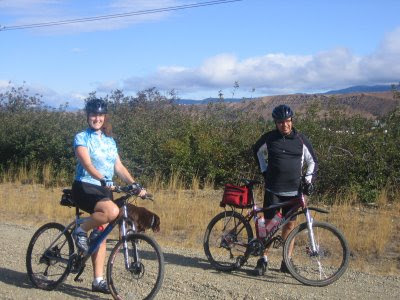
It was a gorgeous morning. Sunny and comfortable with a fairly stiff breeze which would be a tailwind the entire time we were riding. After the cooler temps and clouds of the day before, the sun was wonderful. Everybody was in a good mood and off we went. We'd spotted a farm growing pumpkins and I had to go check it out for a little detour at the beginning.

To get back to the trail I had to go into the wind. Even for that quarter mile on the gravel road, I was very thankful we would have a tailwind.
The trail from Thorp to Kittitas was very uneventful 14 miles. Flat and pretty with nice famland vistas. There was really no one else out and about so I made sure to bark at the dogs and moo at the cows I saw. I called out "good morning!" to the horses in the fields too. My legs were feeling great and even my seat was fine which really surprised me.

From Kittitas, the trail has a super soft sandy/gravel surface which was really challenging to push through on bike. It was easy to bog down and have to walk. I kept looking longingly at the road which paralleled the trail. I was so tempted! But no, Coach T ever the joker had come up with the idea of completing this three day ride meant riding every inch of the trail (which is open) otherwise you wouldn't be "certified." We'd all had a good laugh at that and it was keeping me on the trail (the laugh is on me!).
The trail is actually closed in a short stretch along here because the Renslow Trestle Bridge is unrideable. We took a rolling road detour which was fun to ride after all the sand. I did manage to hit 32 mph going downhill on my knobby tires and I wasn't even pedaling! Up and down, up and down and you could see the trestle in the distance.
The road runs under the trestle and it's a quick turn to get to Army West Trailhead. I could see the support van parked here and I could see a bunch of
Stryker army vehicles around. These are the huge armored transport vehicles! Uh. Ok. What are they doing? Well, it seems like they are conducting some sort of exercise as they are yelling at some people dressed in civilian clothes and firing at them.

I ride up to T and start howling with laughter. We might be done for the day!
T has been talking with the men after initially being told to "Halt!" and "Stop right there!" They are contacting their command about the feasibility of a bunch of bicyclists riding on the trail. Eventually someone comes over and lets us know that the trail is open and points out exactly where to get to it. He does suggest that the army drivers are used to driving around like maniacs out there so you might want to be careful and do not get off the trail.
Ok then! Since the trail goes through this restricted area there is no support vehicle access for the nex

t 20 miles. I fill up my water bottle, have a gel and prepare to ride on. The terrain has changed from valley farmland to dry scrubland. It really looks like Albuquerque much to my surprise and has the same vegetation.
After a short hill to reach the trail, I hop on my bike and start to ride and quickly bog down in even worse sand/gravel than the earlier section. And to make matters worse the trail is slightly uphill. I have to crank on the pedals to get going and keep going and I'm barely moving along at 7.5 mph. I can tell other cyclist have gone through this area by the tracks and I can see when they lost control of their bikes on the loose stuff.

This is tough, tough riding when I'm even riding. It's even hard to walk through this stuff pushing the bike. 20 miles of this?

I do start to get better at riding this stuff though. It's almost like surfing on sand and I am getting a great core workout controlling the twitching, fishtailing bike. The tailwind has picked up and seems to help move me around on the trail when I don't want to be moved. It seems like forever but this section was only about 4 miles long and took me about 50 minutes to ride.
The trail started to become more packed and a little bit more rideable and then the final tunnel of the ride appeared unexpectedly at the end of a very narrow, dark chute which you couldn't see the end of. I knew this tunnel was not very long (1980 feet) but it curved because I couldn't see the end. The surface of the tunnel is super loose sand with huge boulders dotting the ground. Not too far into the tunnel I start to hear twitterings. Uh bats? No worse. Pigeons! My light and movement startle them and they keep flying around me and in front of me and probably above me. I'm yelling "crap, crap, crap!" and thinking that is exactly what they are probably doing. The surface of the trail gets worse the farther into the tunnel you go with big sections of large loose rocks. I am determined to ride through because there is no way I'm stopping. I think this tunnel is worse than the 2.4 miles Snoqualmie one!

The Boyleston Tunnel marks the elevation high point of this trail. From here the next 15 miles are all downhill to the Columbia River. The surface is a lot better but there are still sections of the loose sand. What becomes even more challenging is the cuts through the hillside that were made to keep the railroad grade constant. Those cuts are very narrow and the rock lining them is extremely friable. The ground of these cuts is littered with piles of sharp rocks some even bigger than a, as the term goes, baby head. Loose scree and big rocks and going downhill means this is a dangerous ride. Often you could hear the wind building behind you and whistling through the cuts and when that happened you knew it would push you around. This was challenging riding for me. I've never done anything like this before.
And of course, I did see the army boys driving their Strykers around. I'd wave and they waved back. I, of course, was carefully waiting for them to cross. And I had a laugh at some of the signs warning to stay on the trail.

Army conducting exercises plus rattlesnakes and no roads or other trails in sight? Yep. I'm staying on the trail!
The wind started to get stronger and stronger. The final 5 miles are on curving trails with a mix of the loose stuff. The wind would push you over so much that I'd be afraid of falling off the high banked trail. Even so, it was exhilarating riding at such speeds and leaning into the wind and controlling the fish tailing. I was having a blast and there were sweeping views of the Columbia River.
Done! 41 miles later and my quads and hips were screaming about the abuse I'd put them through. Turns out that some of our riders didn't really have the strength and/or bike skills to do the final section and had to turn back. Others who could do it reported having some emotional breakdowns while in the midst of the challenge. And it was a huge challenge!
We drove back to Ellensburg to shuffle bikes, gear and riders between another vehicle and drove back happy and tired to Seattle. Iron Horse from Seattle to Columbia River for 155 miles? I'm certified and certifiable!


